It is very likely that our Walli, or rather his transmitter, will send us data again only when he reaches an area with good GSM coverage during his spring migration and at the scheduled data transmission time. If we receive new information, we will inform you immediately.
Walli, our juvenile stork, gathered strength before migration on the Mustjõe flood plains and oxbows. After departing from the Mustjõe River area, he made a stop about 30 km south, at the Koiva River flood plains.
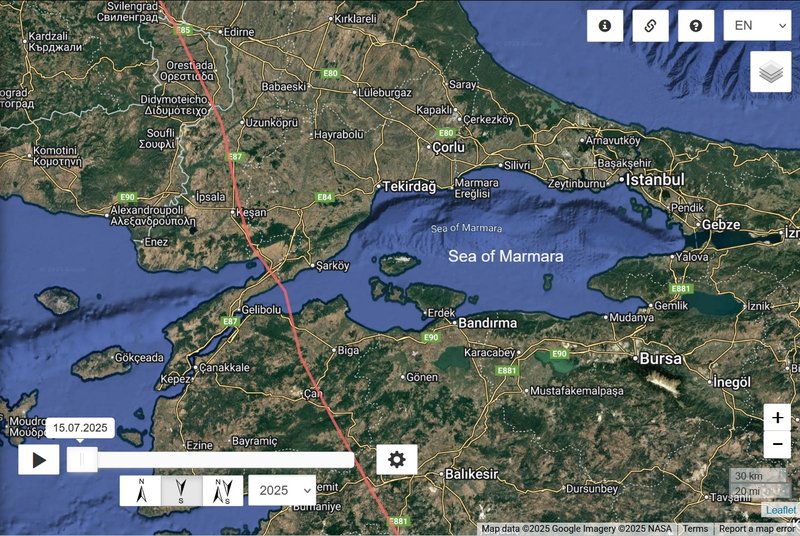
He clearly began his migration on September 5, continuing smoothly toward the Sea of Marmara, with the exception of a 5-day pause caused by unfavourable weather in northern Czech Republic. Walli crossed the Sea of Marmara via the Dardanelles on September 20.
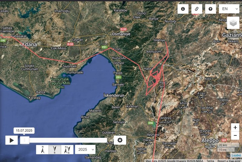
The following four days were spent crossing Anatolia (Asian Turkey), and then one additional day skirting around the Gulf of İskenderun. Walli flew over the Nur Mountains and made a longer stopover in the Hatay district, from September 25 to October 11.
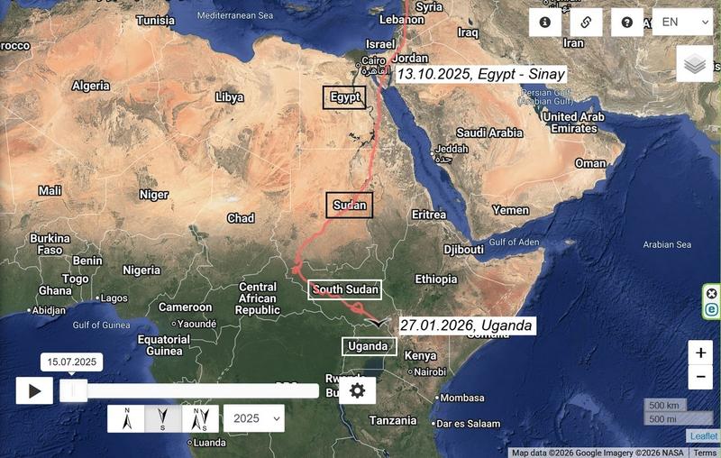
After this stop-over, he resumed his journey southward. Over the next three days, Walli crossed the Levant region (Syria–Lebanon–Israel corridor), heading toward the Suez Canal — the gateway to Africa.
Unfortunately, in Egypt’s North Sinai Governorate, data transmission ceased — as has happened with other storks before. It’s highly likely that Walli has already reached his wintering grounds somewhere further south, where GPS signal or data coverage tends to be unreliable.
Fingers crossed very, very much!
Walli (2025) - from unknown nest (maybe even from Latvia)
-
marika.solo
- Site Admin
- Posts: 23253
- Joined: 29 Sep 2021, 09:38
-
marika.solo
- Site Admin
- Posts: 23253
- Joined: 29 Sep 2021, 09:38
Re: Walli (2025) - from unknown nest (maybe even from Latvia)
LAST birdmap update: viewtopic.php?p=52540#p52540
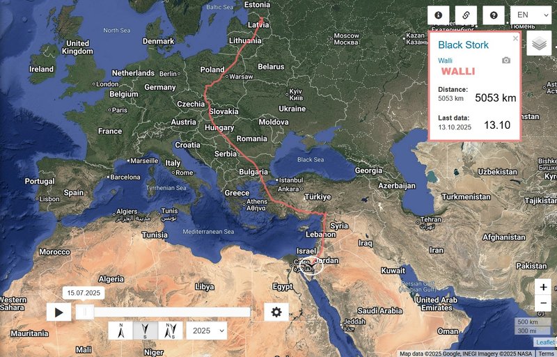
- 13.10, Distance: 5053 km (+ 308 km)
- EGYPT/Sinai: El Tahmad - in Qesm Nakhl municipal division (Al-Qasīmah / Shurtet El Qasima), North Sinai Governorate
(north of El Tahmad)
Walli and the Sea of Marmara
Walli and the Gulf of İskenderun
- 13.10, Distance: 5053 km (+ 308 km)
- EGYPT/Sinai: El Tahmad - in Qesm Nakhl municipal division (Al-Qasīmah / Shurtet El Qasima), North Sinai Governorate
(north of El Tahmad)
Walli and the Sea of Marmara
Walli and the Gulf of İskenderun
-
marika.solo
- Site Admin
- Posts: 23253
- Joined: 29 Sep 2021, 09:38
Re: Walli (2025) - from unknown nest (maybe even from Latvia)
BREAKING NEWS: Walli the Black Stork Update after 106 days!
We’ve just received brand new data from Walli!
JANUARY 27
Hello everyone
LAST birdmap update: viewtopic.php?p=52540#p52540
- 13.10, Distance: 5053 km (+ 308 km)
- EGYPT/Sinai: El Tahmad - in Qesm Nakhl municipal division (Al-Qasīmah / Shurtet El Qasima), North Sinai Governorate
(north of El Tahmad)
NEW data:
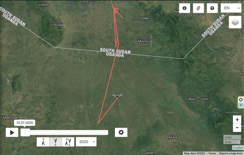
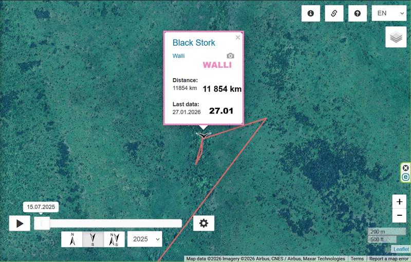
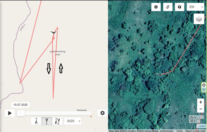
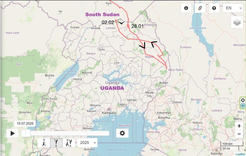
- 27.01.2026, Distance: 11854 km (+ km)
- UGANDA: Kitgum - a municipality in Kitgum District in the Northern Region
(there is the Lipan Hunting Area)
We’ve just received brand new data from Walli!
JANUARY 27
Hello everyone
LAST birdmap update: viewtopic.php?p=52540#p52540
- 13.10, Distance: 5053 km (+ 308 km)
- EGYPT/Sinai: El Tahmad - in Qesm Nakhl municipal division (Al-Qasīmah / Shurtet El Qasima), North Sinai Governorate
(north of El Tahmad)
NEW data:
- 27.01.2026, Distance: 11854 km (+ km)
- UGANDA: Kitgum - a municipality in Kitgum District in the Northern Region
(there is the Lipan Hunting Area)
-
marika.solo
- Site Admin
- Posts: 23253
- Joined: 29 Sep 2021, 09:38
-
marika.solo
- Site Admin
- Posts: 23253
- Joined: 29 Sep 2021, 09:38
Re: Walli (2025) - from unknown nest (maybe even from Latvia)
January 28
Hello everyone
Previous data:
- 27.01.2026, Distance: 11854 km (+ km)
- UGANDA: Kitgum - a municipality in Kitgum District in the Northern Region
(there is the Lipan Hunting Area)
NEW data
- 28.01.2026, Distance: 11879 km (+ 25 km)
- Uganda: Kitgum - a municipality in Kitgum District in the Northern Region
(there is the Lipan Hunting Area)
-
marika.solo
- Site Admin
- Posts: 23253
- Joined: 29 Sep 2021, 09:38
Re: Walli (2025) - from unknown nest (maybe even from Latvia)
February 02
Hello everyone
Previous data:
- 28.01.2026, Distance: 11879 km (+ 25 km)
- Uganda: Kitgum - a municipality in Kitgum District in the Northern Region
(there is the Lipan Hunting Area)
NEW data
- 02.02.2026, Distance: 12614 km (+ 735 in 5 days/147 km per day - "trip" to SE and back)
- Uganda: Agoro - a village in Lamwo District in the Northern Region
-
marika.solo
- Site Admin
- Posts: 23253
- Joined: 29 Sep 2021, 09:38
Re: Walli (2025) - from unknown nest (maybe even from Latvia)
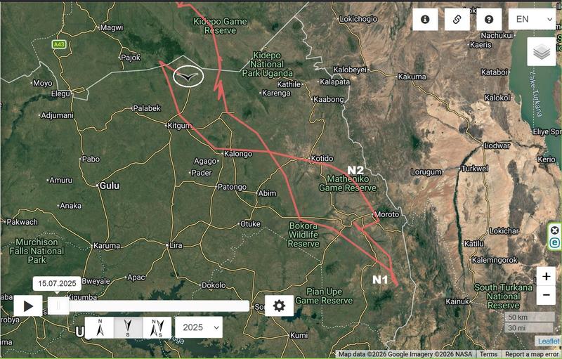
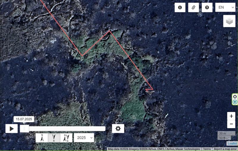
The only two clear places to stay overnight that I found
N1
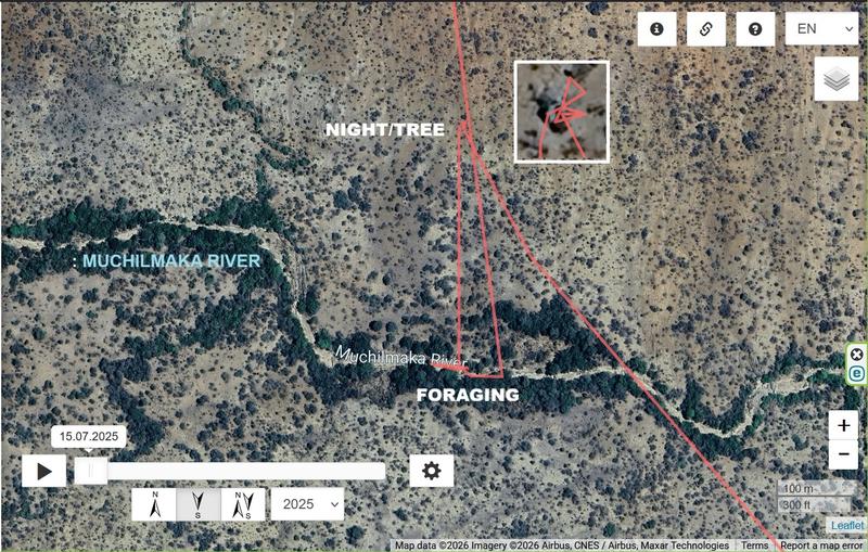
N2
N1
N2
-
marika.solo
- Site Admin
- Posts: 23253
- Joined: 29 Sep 2021, 09:38
Re: Walli (2025) - from unknown nest (maybe even from Latvia)
and Walli is back in the north of Uganda
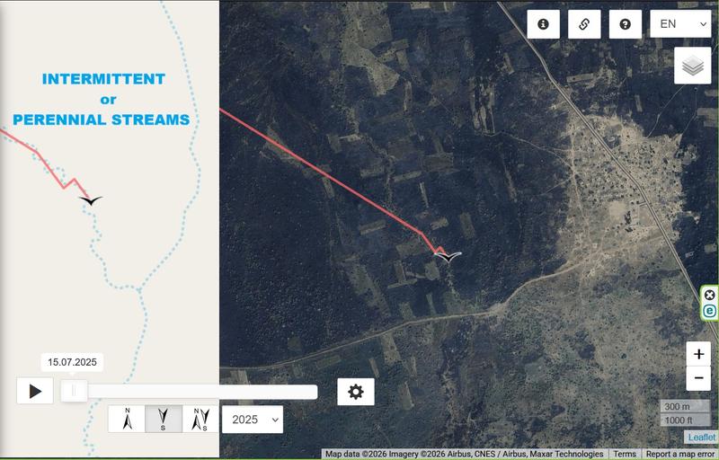
https://hydro.tn.gov/pages/hydrography-faq, https://www.transect.com/insights/stream-classification (also other Types of Stream Classifications)
STREAM: A stream is a continuous body of surface water flowing within the bed and banks of a channel. Depending on its location or certain characteristics, a stream may be referred to by a variety of local or regional names. Long, large streams are usually called rivers, while smaller, less voluminous and more intermittent streams are known as streamlets, brooks or creeks.
Perennial Stream: The basic concept means flowing bodies of water. In hydrology, the stream usually refers to water flowing through natural passages separated from canals. A Perennial Stream (or perennial river) is categorized by year-round stream flow in parts of its stream bed. This assessment assumes normal rainfall, as climate change impacts how these streams are classified. These streams are called a “permanent stream” because they are clear and continuous compared to a “temporary stream,” such as ephemeral and intermittent streams.
Intermittent / Seasonnal Stream: Intermittent stream means a stream or part of a stream that has flowing water during certain times of the year when groundwater provides water for streamflow. The water table is located above the streambed for only part of the year, which means that intermittent streams may not have flowing water during dry periods. The dry period is the main distinguishing characteristic used for intermittent and perennial stream classification.
Ephemeral Stream: An ephemeral stream has flowing water only during, and for a short duration after, precipitation events in a typical year. Ephemeral stream beds are located above the water table year-round. Groundwater is not a source of water for the stream. Ephemeral streams rely on stormflow.
Wet Weather Conveyance: “Daily flow and precipitation records showing feature only flows in direct response to rainfall” : If a watercourse only flows in direct response to rainfall, and does not carry flow for an extended period of time in an average year (and meets the other conditions of the WWC definition), it is a wet weather conveyance.