birdmap update Sep 02
NEW data
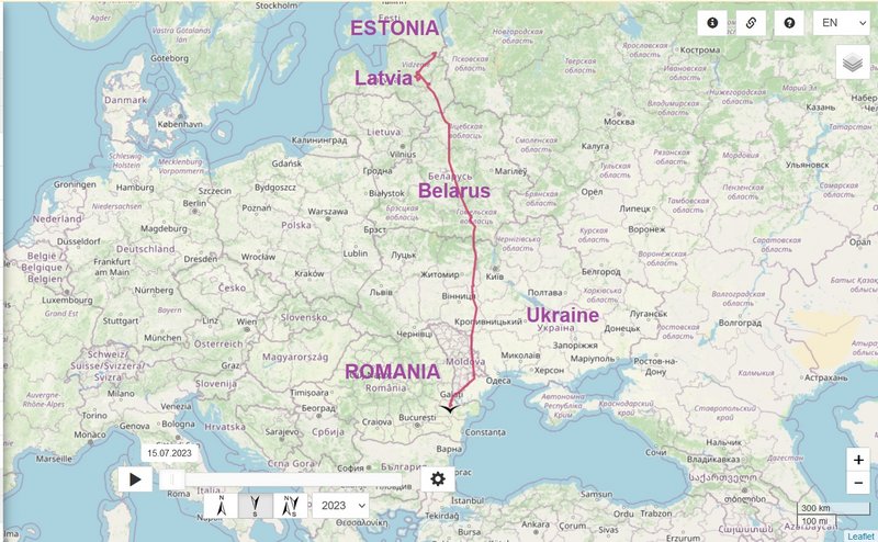
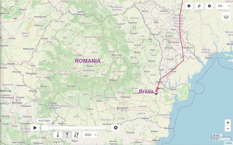
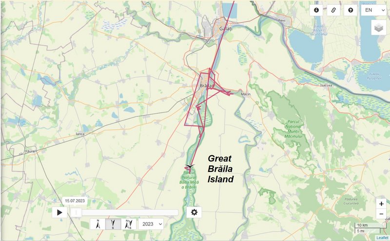
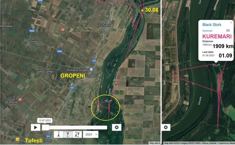
- 01.09.2023, Distance: 1909 km (+ 22 km)
- ROMANIA: between Gropeni and Tufești, in the area of the Balta Mică a Brăilei Natural Park
Kuremari moved not far to the south
KUREMARI, (fe)male
-
marika.solo
- Site Admin
- Posts: 26541
- Joined: 29 Sep 2021, 09:38
Re: KUREMARI, (fe)male
previous data: Aug 30 viewtopic.php?p=23994#p23994
next data: Sep 01 viewtopic.php?p=24145#p24145
September 01 data
Hello everyone
Birdmap update for KUREMARI
https://birdmap.5dvision.ee/EN/2023/aut ... =0&speed=1
Previous data:
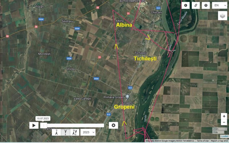
- 30.08.2023, Distance: 1887 km (+ 11 km)
- ROMANIA: Tichilești - a commune (composed of two villages, Albina and Tichilești) in Brăila County
NEW data:
- 01.09.2023, Distance: 1909 km (+ 22 km in 2 days)
- ROMANIA: between Gropeni and Tufești, in the area of the Balta Mică a Brăilei Natural Park
next data: Sep 01 viewtopic.php?p=24145#p24145
September 01 data
Hello everyone
Birdmap update for KUREMARI
https://birdmap.5dvision.ee/EN/2023/aut ... =0&speed=1
Previous data:
- 30.08.2023, Distance: 1887 km (+ 11 km)
- ROMANIA: Tichilești - a commune (composed of two villages, Albina and Tichilești) in Brăila County
NEW data:
- 01.09.2023, Distance: 1909 km (+ 22 km in 2 days)
- ROMANIA: between Gropeni and Tufești, in the area of the Balta Mică a Brăilei Natural Park
-
marika.solo
- Site Admin
- Posts: 26541
- Joined: 29 Sep 2021, 09:38
Re: KUREMARI, (fe)male
Kuremari is moving in the are of Balta Mică a Brăilei Natural Park (Parcul Natural Balta Mică a Brăilei)
Ramsar site - Small Island of Braila https://rsis.ramsar.org/ris/1074:
A group of wetlands in the Lower Danube region, one of the rare areas along the river that has preserved its natural hydrological conditions and which contains a representative sample of habitats characteristic of floodplains as well as a former inland delta. Comprising seven small islands stretching over 61 km between two arms of the Danube just south (upstream) of Braila ... The adjacent "Big Island of Braila", five times greater in size, was largely drained during the previous political era.
IBA - Little Island of Braila/Balta Mică a Brăilei http://datazone.birdlife.org/site/facts ... ba-romania:
A wetland complex of many lakes linked by canals and marshes, situated in the Danube valley. There are open grassy areas with lines of Salix trees and also areas of riverine forest. The water-level varies according to the Danube's level and spring floods are common. The island also has agricultural crops, meadows and pasture. There are only a few small human settlements.
24 min. long very nice video
source: https://bmb.ro/
eng version https://bmb.ro/index.php/en/home/:
photo galley https://bmb.ro/index.php/galerie-foto-pnbmb/ - black storks:

-
marika.solo
- Site Admin
- Posts: 26541
- Joined: 29 Sep 2021, 09:38
Re: KUREMARI, (fe)male
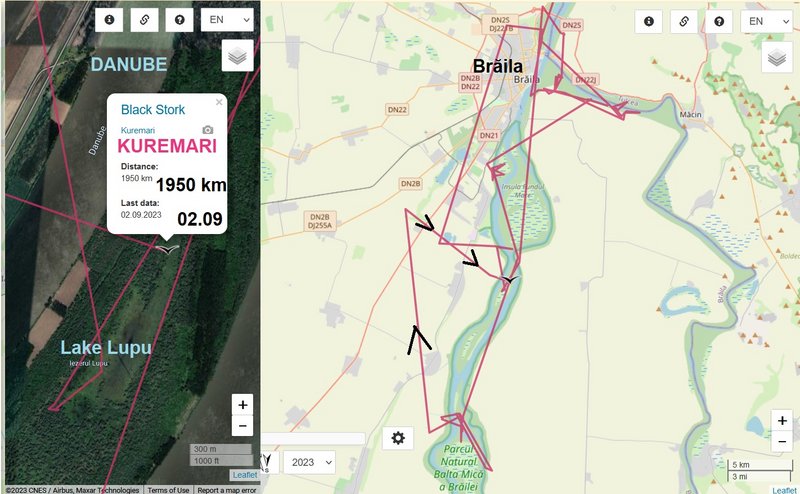
birdmap update 02.09/second
NEW data:
- 02.09.2023, Distance: 1950 km (+ 41 km)
- ROMANIA: Tichilești - a commune (composed of two villages, Albina and Tichilești) in Brăila County
Kuremari is flying today one bigger triangle trip to NW and is back in the Small Braila Island area to the east from Tichilești
NEW data:
- 02.09.2023, Distance: 1950 km (+ 41 km)
- ROMANIA: Tichilești - a commune (composed of two villages, Albina and Tichilești) in Brăila County
Kuremari is flying today one bigger triangle trip to NW and is back in the Small Braila Island area to the east from Tichilești
-
marika.solo
- Site Admin
- Posts: 26541
- Joined: 29 Sep 2021, 09:38
Re: KUREMARI, (fe)male
previous data: Sep 01 viewtopic.php?p=24130#p24130
next data: 03 viewtopic.php?p=24186#p24186
September 02 data
Hello everyone
Birdmap update for KUREMARI
https://birdmap.5dvision.ee/EN/2023/aut ... =0&speed=1
Previous data:
- 01.09.2023, Distance: 1909 km (+ 22 km in 2 days)
- ROMANIA: between Gropeni and Tufești, in the area of the Balta Mică a Brăilei Natural Park
NEW data:
- 02.09.2023, Distance: 1950 km (+ 41 km)
- ROMANIA: Tichilești - a commune (composed of two villages, Albina and Tichilești) in Brăila County
today "trip"
-
marika.solo
- Site Admin
- Posts: 26541
- Joined: 29 Sep 2021, 09:38
Re: KUREMARI, (fe)male
Kuremari's path-line is above this area
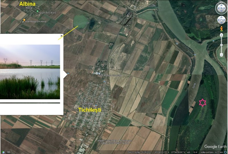
Comuna Tichilești
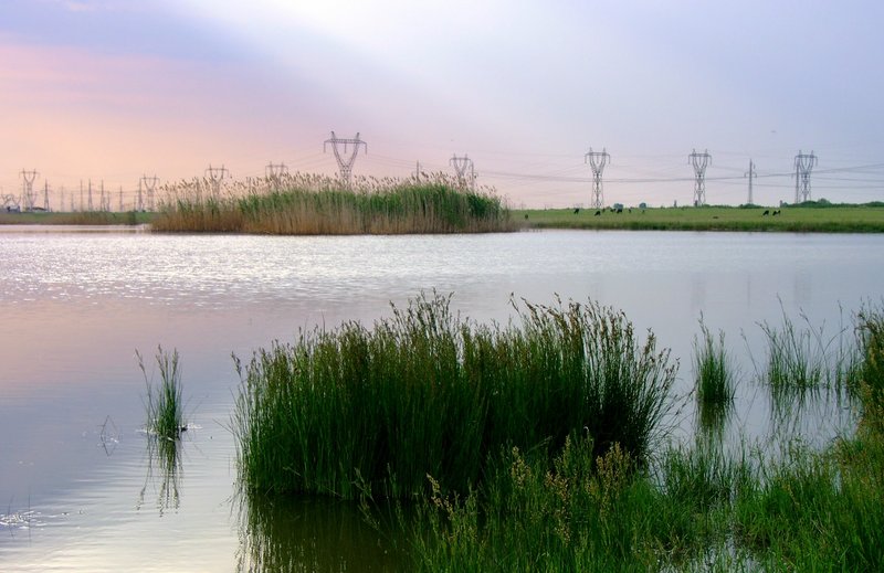
big PHOTO https://lh5.googleusercontent.com/p/AF1 ... rQxL=h1440 by Werner Funk
Comuna Tichilești
big PHOTO https://lh5.googleusercontent.com/p/AF1 ... rQxL=h1440 by Werner Funk
-
marika.solo
- Site Admin
- Posts: 26541
- Joined: 29 Sep 2021, 09:38
Re: KUREMARI, (fe)male
previous data: Sep 02 viewtopic.php?p=24134#p24134
next data: XY
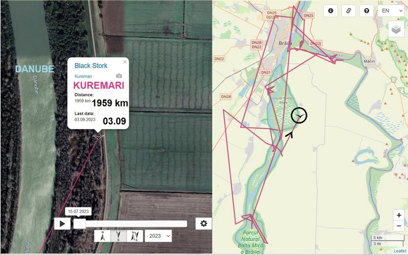
September 03 data
Hello everyone
Birdmap update for KUREMARI
https://birdmap.5dvision.ee/EN/2023/aut ... =0&speed=1
Previous data:
- 02.09.2023, Distance: 1950 km (+ 41 km)
- ROMANIA: Tichilești - a commune (composed of two villages, Albina and Tichilești) in Brăila County
NEW data:
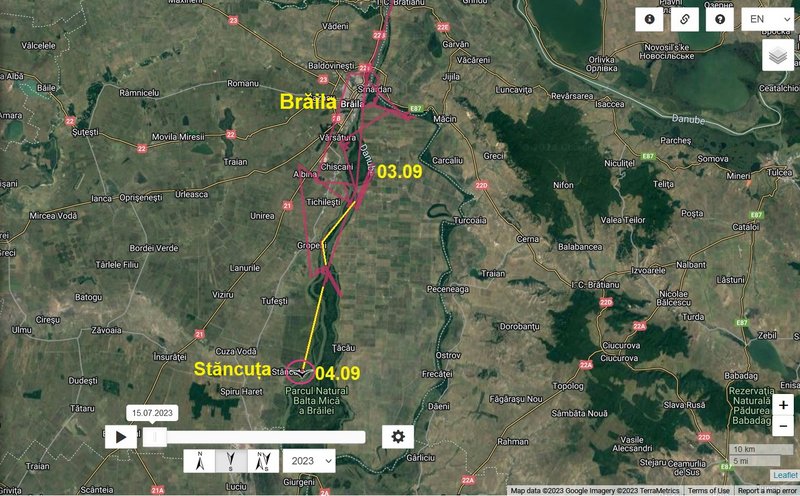
- 03.09.2023, Distance: 1959 km (+ 9 km)
- ROMANIA: Big Brăila Island (shore area of the river Danube)
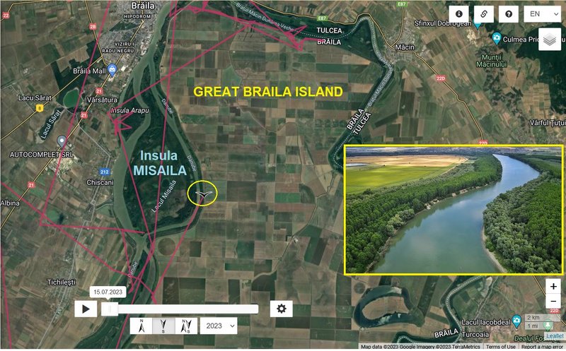
in my opinion, the photo is uploaded probably the other way around https://lh5.googleusercontent.com/p/AF1 ... 318-n-k-no
view on one of the islands
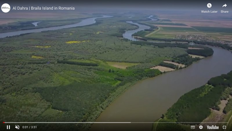
pic from VIDEO https://youtu.be/2c8pv2dXuco?si=fBzz51lYHktk0m0f
The majority stake in Agricost, which manages the Big Island Farm of Braila, was sold, the seller was Constatin Duluţe, who took over the business of Cultiţă Trăţă. The buyer was Al Dahra from the United Arab Emirates, which belonged to Sheikh Hamdan Bin Zayed Al Nahyan
The businessman Constantin Duluţe is represented in the top 300 of the richest Romanians. Constantin Duluţe occupies the 86th place with an estimated fortune between 65 and 67 million euros.
Constantin Duluţe remains a minority shareholder in this transaction and is committed to massive purchases of agricultural land. A company in the United Arab Emirates will expand its livestock farms raising, slaughtering and processing sheep.
Transaction Price: "Between 200 and 250 million, I can not tell the percentage because I have not signed the contract yet, it's just a transaction between private entities, not to sell the land on the island is the state that sells the business Palma I beat them as we agreed to the general clauses, "says Duluţe, for Capital. source https://newsbeezer.com/romaniaeng/the-b ... ion-euros/
next data: XY
September 03 data
Hello everyone
Birdmap update for KUREMARI
https://birdmap.5dvision.ee/EN/2023/aut ... =0&speed=1
Previous data:
- 02.09.2023, Distance: 1950 km (+ 41 km)
- ROMANIA: Tichilești - a commune (composed of two villages, Albina and Tichilești) in Brăila County
NEW data:
- 03.09.2023, Distance: 1959 km (+ 9 km)
- ROMANIA: Big Brăila Island (shore area of the river Danube)
in my opinion, the photo is uploaded probably the other way around https://lh5.googleusercontent.com/p/AF1 ... 318-n-k-no
view on one of the islands
pic from VIDEO https://youtu.be/2c8pv2dXuco?si=fBzz51lYHktk0m0f
The majority stake in Agricost, which manages the Big Island Farm of Braila, was sold, the seller was Constatin Duluţe, who took over the business of Cultiţă Trăţă. The buyer was Al Dahra from the United Arab Emirates, which belonged to Sheikh Hamdan Bin Zayed Al Nahyan
The businessman Constantin Duluţe is represented in the top 300 of the richest Romanians. Constantin Duluţe occupies the 86th place with an estimated fortune between 65 and 67 million euros.
Constantin Duluţe remains a minority shareholder in this transaction and is committed to massive purchases of agricultural land. A company in the United Arab Emirates will expand its livestock farms raising, slaughtering and processing sheep.
Transaction Price: "Between 200 and 250 million, I can not tell the percentage because I have not signed the contract yet, it's just a transaction between private entities, not to sell the land on the island is the state that sells the business Palma I beat them as we agreed to the general clauses, "says Duluţe, for Capital. source https://newsbeezer.com/romaniaeng/the-b ... ion-euros/
-
marika.solo
- Site Admin
- Posts: 26541
- Joined: 29 Sep 2021, 09:38
Re: KUREMARI, (fe)male
Braila Islands is split into two, Big Island of Braila and Small Island of Braila respectively. 205 km2 of the total area of the Small Island of Braila is recognized as protected, both on a national level (Natural park - 06/03/2000) and on an international level (Ramsar - 15/06/2001).
Once a former wetland, the Big Island of Braila consists of heavily modified ecosystems with 96.4% of the area been converted into agricultural land. Prior to the conversion to agricultural land, the Big Braila Island was a former wetland, part of the Danube floodplain with a large numbers of lakes, ponds and marshes that were linked to each other and connected to the river (Vadineanu et al., 2003).
On the other hand, the Small Island of Braila maintains ecosystems under a natural functional regime and has preserved its natural hydrological conditions. It is the main remnant of floodplains in the area, making it crucial to preserve (European Communities, 2002).
(source: https://www.interreg-danube.eu/news-and ... vents/6035)
-
marika.solo
- Site Admin
- Posts: 26541
- Joined: 29 Sep 2021, 09:38
Re: KUREMARI, (fe)male
previous data: Sep 03 viewtopic.php?p=24186#p24186
next data: Sep 05 viewtopic.php?p=24237#p24237
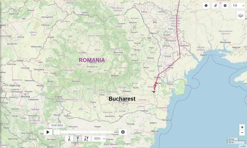
September 04 data
Hello everyone
Birdmap update for KUREMARI
https://birdmap.5dvision.ee/EN/2023/aut ... =0&speed=1
Previous data:
- 03.09.2023, Distance: 1959 km (+ 9 km)
- ROMANIA: Big Brăila Island (shore area of the river Danube)
NEW data:
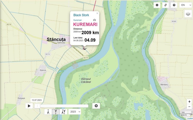
- 04.09.2023, Distance: 2009 km (+ 50 km)
- ROMANIA: Stăncuța - a village in Stăncuța commune located in Brăila County, Muntenia
(Stăncuța commune is composed of four villages: Cuza Vodă, Polizești, Stanca and Stăncuța.)
Kuremari moved to the south in this area
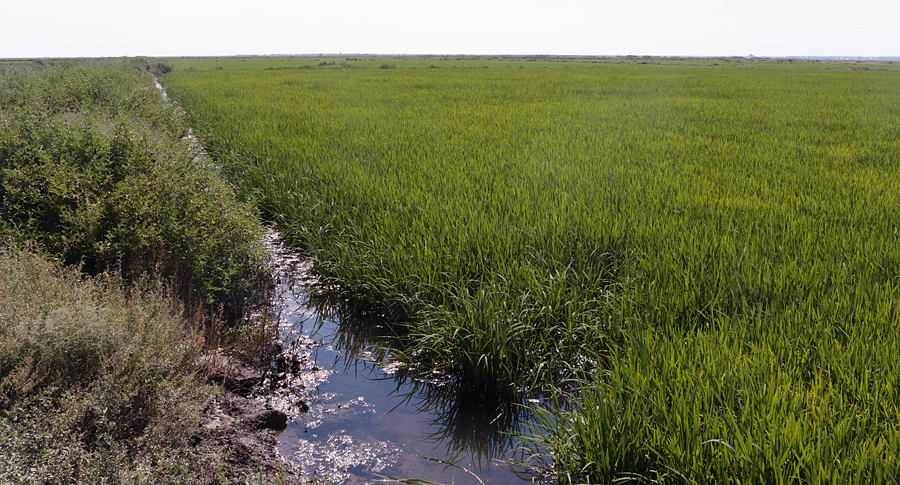
these are abandoned rice fields with melioration canals (https://www.puterea.ro/orezaria-de-la-s ... licitatie/)
very distance view to the newest localisation https://goo.gl/maps/5riLmxqvXTiNKiGv9 (you can rotating the view and to see the canals with water)
next data: Sep 05 viewtopic.php?p=24237#p24237
September 04 data
Hello everyone
Birdmap update for KUREMARI
https://birdmap.5dvision.ee/EN/2023/aut ... =0&speed=1
Previous data:
- 03.09.2023, Distance: 1959 km (+ 9 km)
- ROMANIA: Big Brăila Island (shore area of the river Danube)
NEW data:
- 04.09.2023, Distance: 2009 km (+ 50 km)
- ROMANIA: Stăncuța - a village in Stăncuța commune located in Brăila County, Muntenia
(Stăncuța commune is composed of four villages: Cuza Vodă, Polizești, Stanca and Stăncuța.)
Kuremari moved to the south in this area
these are abandoned rice fields with melioration canals (https://www.puterea.ro/orezaria-de-la-s ... licitatie/)
very distance view to the newest localisation https://goo.gl/maps/5riLmxqvXTiNKiGv9 (you can rotating the view and to see the canals with water)
-
marika.solo
- Site Admin
- Posts: 26541
- Joined: 29 Sep 2021, 09:38
Re: KUREMARI, (fe)male
the Latvian female Mare spent there long time (I still miss she very, very much)
GT translation
the rice fields there
Rīsa lauks būtībā ir dīķis, kam pa perimetru ir tīrs notekgrāvītis ar ūdeni (kurā ir zivis), bet visu platību klāj rīsi.
A paddy field is basically a pond with a clean ditch of water around the perimeter (with fish in it), but the entire area is covered by rice.
source https://goris.lv/mares-stasts/ by Dr. M. Strazds
Melno stārķu te ir „kā dubļu” – vienā pašā Mares „dīķī” Emanuēls saskaita 23, bet visus neredz, arī raidītāju nevienam putnam nepamanām.
There are black storks here "like mud" - in one Mare "pond" Emanuel counts 23, but he does not see all of them, nor do we notice the transmitter of any bird.
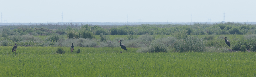
source https://goris.lv/mares-stasts/ by Dr. M. Strazds
Dīķos ir milzīga putnu bagātība, visvairāk te ir brūno ibisu, kuru barā lidojošu melno stārķi var arī nepamanīt. Nemaz tik atšķirīga lieluma viņi nav.
There is a huge wealth of birds in the ponds, mostly glossy ibis (Plegadis falcinellus), in the flock of which you may not notice a flying black stork. They are not that different in size.
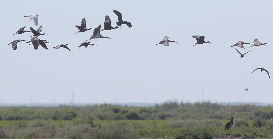
source https://goris.lv/mares-stasts/ by Dr. M. Strazds
GT translation
the rice fields there
Rīsa lauks būtībā ir dīķis, kam pa perimetru ir tīrs notekgrāvītis ar ūdeni (kurā ir zivis), bet visu platību klāj rīsi.
A paddy field is basically a pond with a clean ditch of water around the perimeter (with fish in it), but the entire area is covered by rice.
source https://goris.lv/mares-stasts/ by Dr. M. Strazds
Melno stārķu te ir „kā dubļu” – vienā pašā Mares „dīķī” Emanuēls saskaita 23, bet visus neredz, arī raidītāju nevienam putnam nepamanām.
There are black storks here "like mud" - in one Mare "pond" Emanuel counts 23, but he does not see all of them, nor do we notice the transmitter of any bird.
source https://goris.lv/mares-stasts/ by Dr. M. Strazds
Dīķos ir milzīga putnu bagātība, visvairāk te ir brūno ibisu, kuru barā lidojošu melno stārķi var arī nepamanīt. Nemaz tik atšķirīga lieluma viņi nav.
There is a huge wealth of birds in the ponds, mostly glossy ibis (Plegadis falcinellus), in the flock of which you may not notice a flying black stork. They are not that different in size.
source https://goris.lv/mares-stasts/ by Dr. M. Strazds