STOP OVER (favourite places - info, photo, video)
A stopover in bird migration is a temporary location where birds pause their journey to rest, refuel, and seek shelter. These crucial sites allow birds to gain the energy and nutrients needed to continue their long flights. Stopover habitats must provide reliable food sources, as well as safe resting areas.
STOP OVER (favourite places - info, photo, video)
-
marika.solo
- Site Admin
- Posts: 21537
- Joined: 29 Sep 2021, 09:38
-
marika.solo
- Site Admin
- Posts: 21537
- Joined: 29 Sep 2021, 09:38
Re: STOP OVER (favourite places - info, photo, video)
ROMANIA
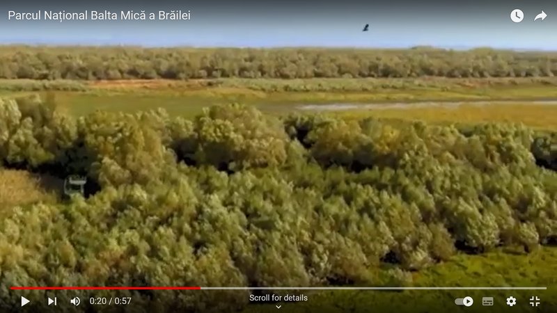
Balta Mică a Brăilei Natural Park is a protected area (the Small Brăila Island) which is situated in Romania, in Brăila County, on the administrative territory of communes Berteștii de Jos, Chiscani, Gropeni, Mărașu and Stăncuța - https://en.wikipedia.org/wiki/Balta_Mic ... tural_Park; or here: https://eunis.eea.europa.eu/sites/63626[/size])
very good description and photos: https://www.birdingplaces.eu/en/birding ... -a-brailei
Parcul Natural "Balta Mică a Brăila (PN-BmB) / Balta Mică a Brăilei Natural Park
some info and video already here: viewtopic.php?p=38903#p38903
The park consists of a chain of 7 large Danube islands (with areas between 242 ha – Harapu island and 9,727 ha – Insula Mică a Brăila island), separated by 7 arms of the Danube totaling a length of 149 km watercourse. The 7 large islands consist of 4,466 ha of aquatic habitats (grouped in 52 inland lakes) and 10,709 ha of terrestrial habitats.
(Insula/romanian = Island):
1/ Insula Vărsătura,
2/ Insula Mică a Brăilei (Small Island of Brăila),
3/ Insula Crăcănel (Trăsura sau Chiciu),
4/ Insula (Chiciul) Orbului,
5/ Insula Lupului (Calia sau Caleia),
6/Insula Fundu Mare,
7/ Insula (H)Arapu.
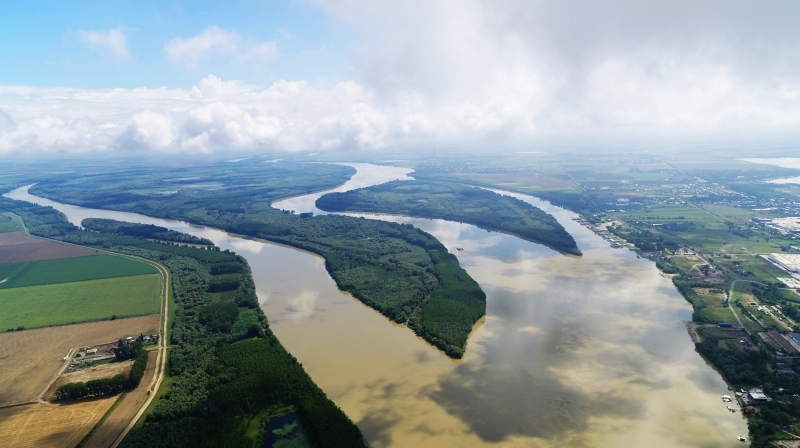
The Small Island of Braila, declared a natural reserve in 1994, is a group of wetlands in the Lower Danube area. This is one of the rare areas bordering the river which has preserved its natural hydrological conditions and which contains a representative sample of habitats, which are characteristic of floodplains as well as an ancient inland delta. Comprising seven small islands with a total surface area of 17 .586 hectares, the area is a site of major interest for birds, both for the quality of the habitats present and for its location on the migration routes midway between the nesting areas in the north of Europe and the wintering areas in Africa.
Small Island of Braila is a component of Lower Danube System, a key complex of wetland ecosystems ... Small Island of Braila,
represents a real internal delta ... Located along the Danube River between km 175 (marika: the municipality of Brăila - km 175 downstream) and 237 (marika: the Giurgeni-Vadu Oii road bridge - km 237 on the Danube upstream) in the Braila County.
The nearest large town, Braila is located in the northern part of the Small Island of Braila. With a total length of 61-km, represent the remained naturally flooded area after the building of a dike (151-km length) that changed the most part (75%) of the former "Braila Marsh".
On the remained flooded area of about 23000 ha, the most important area is called "The Small Island of Braila" (17000 ha), delimited by secondary arm (Valciu, Manusoaia, Calia, Cravia) and navigable arm of the Danube river, situated in the Braila county.
(https://rsis.ramsar.org/RISapp/files/RI ... 074RIS.pdf)
https://www.qreferat.com/referate/geogr ... -BR718.php
near Smârdan

pic form VIDEO: Plimbare cu motodeltaplanul pe Bratul Macin - Dunarea Veche (Ride with the hang glider on Bratul Macin - Old Danube) https://youtu.be/YKkO_efg3k4 uploaded on 29 Jul 2015 by Cristian Deceanu
zoomed street view (same area)

STREET VIEW https://goo.gl/maps/r9FvxescmSq3Q53h8 by Balaes Leopold Jul 2019
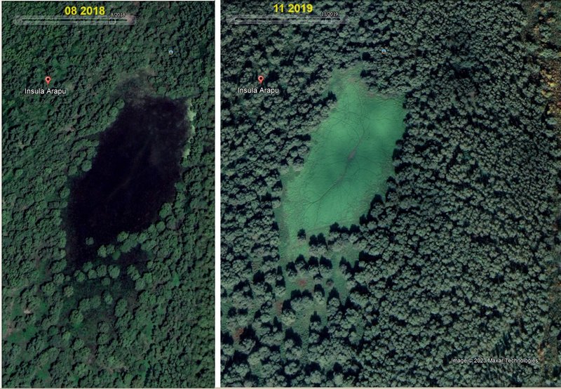
(HA)RAPU Island
(source: https://www.albayan.ae/economy/local-ma ... -1.3365790)
this place can be more wet or more dry around the year
(illustration)
pic from this VIDEO https://youtu.be/q_l0HPaUDqE?feature=shared uploaded on 02 Nov 2019 by Balan Claudiu
(illustration)
illustration - view on the floodplain between the river bank and the drikes
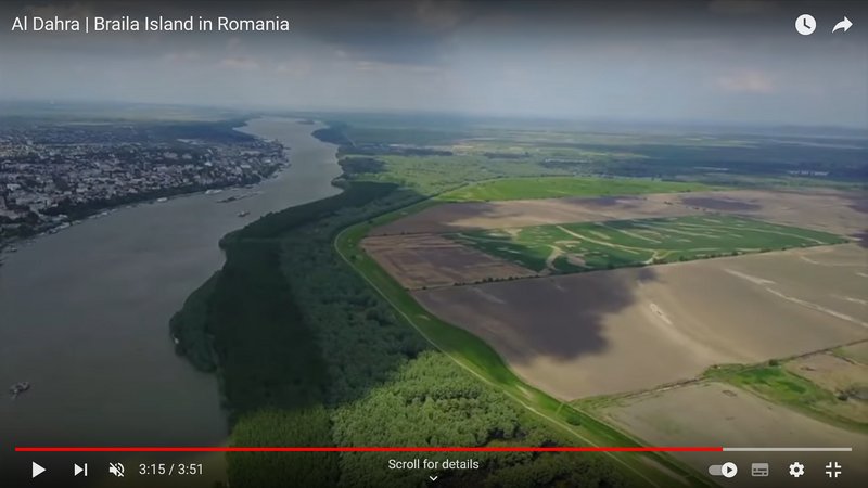
VIDEO https://youtu.be/2c8pv2dXuco?feature=shared uploaded on 16.09.2018 by Al Dahra
How the area changed on the Big/Great Brăila Island
(Romanian: Insula Mare a Brăilei - Balta Mică a Brăilei Natural Park is located on the Small Brăila Island)
The Great Brăila Island (Romanian: Insula Mare a Brăilei) is an island on the Danube river in the Brăila County, Romania. It has on average 57.9 km length and 18.6 km width, with a total area of 710 km². The two river branches which separate it from the mainland are Măcin Branch and Vâlciu Branch.
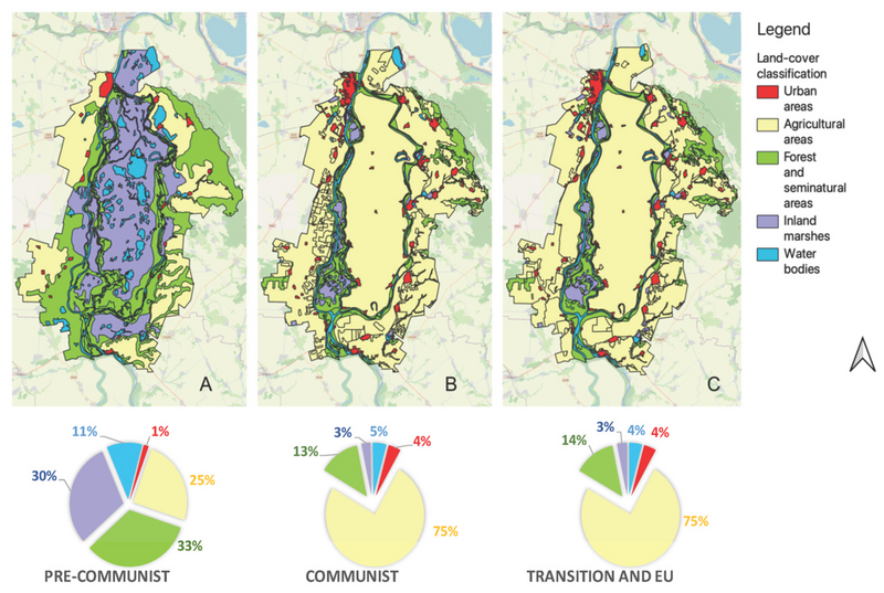
source: Racoviceanu, T., Cazacu, C., Adamescu, M., Giucă, R., Bucur, M., Fedoriak, M., & Angelstam, P. (2023). Agricultural Intensification Reduces the Portfolio of Wetland Ecosystem Services: European Danube River Lowlands as a Global Biodiversity Hotspot. Land, 12(3), 722. MDPI AG. Retrieved from http://dx.doi.org/10.3390/land1203072
Balta Mică a Brăilei Natural Park is a protected area (the Small Brăila Island) which is situated in Romania, in Brăila County, on the administrative territory of communes Berteștii de Jos, Chiscani, Gropeni, Mărașu and Stăncuța - https://en.wikipedia.org/wiki/Balta_Mic ... tural_Park; or here: https://eunis.eea.europa.eu/sites/63626[/size])
very good description and photos: https://www.birdingplaces.eu/en/birding ... -a-brailei
Parcul Natural "Balta Mică a Brăila (PN-BmB) / Balta Mică a Brăilei Natural Park
some info and video already here: viewtopic.php?p=38903#p38903
The park consists of a chain of 7 large Danube islands (with areas between 242 ha – Harapu island and 9,727 ha – Insula Mică a Brăila island), separated by 7 arms of the Danube totaling a length of 149 km watercourse. The 7 large islands consist of 4,466 ha of aquatic habitats (grouped in 52 inland lakes) and 10,709 ha of terrestrial habitats.
(Insula/romanian = Island):
1/ Insula Vărsătura,
2/ Insula Mică a Brăilei (Small Island of Brăila),
3/ Insula Crăcănel (Trăsura sau Chiciu),
4/ Insula (Chiciul) Orbului,
5/ Insula Lupului (Calia sau Caleia),
6/Insula Fundu Mare,
7/ Insula (H)Arapu.
The Small Island of Braila, declared a natural reserve in 1994, is a group of wetlands in the Lower Danube area. This is one of the rare areas bordering the river which has preserved its natural hydrological conditions and which contains a representative sample of habitats, which are characteristic of floodplains as well as an ancient inland delta. Comprising seven small islands with a total surface area of 17 .586 hectares, the area is a site of major interest for birds, both for the quality of the habitats present and for its location on the migration routes midway between the nesting areas in the north of Europe and the wintering areas in Africa.
Small Island of Braila is a component of Lower Danube System, a key complex of wetland ecosystems ... Small Island of Braila,
represents a real internal delta ... Located along the Danube River between km 175 (marika: the municipality of Brăila - km 175 downstream) and 237 (marika: the Giurgeni-Vadu Oii road bridge - km 237 on the Danube upstream) in the Braila County.
The nearest large town, Braila is located in the northern part of the Small Island of Braila. With a total length of 61-km, represent the remained naturally flooded area after the building of a dike (151-km length) that changed the most part (75%) of the former "Braila Marsh".
On the remained flooded area of about 23000 ha, the most important area is called "The Small Island of Braila" (17000 ha), delimited by secondary arm (Valciu, Manusoaia, Calia, Cravia) and navigable arm of the Danube river, situated in the Braila county.
(https://rsis.ramsar.org/RISapp/files/RI ... 074RIS.pdf)
https://www.qreferat.com/referate/geogr ... -BR718.php
near Smârdan
pic form VIDEO: Plimbare cu motodeltaplanul pe Bratul Macin - Dunarea Veche (Ride with the hang glider on Bratul Macin - Old Danube) https://youtu.be/YKkO_efg3k4 uploaded on 29 Jul 2015 by Cristian Deceanu
zoomed street view (same area)
STREET VIEW https://goo.gl/maps/r9FvxescmSq3Q53h8 by Balaes Leopold Jul 2019
(HA)RAPU Island
(source: https://www.albayan.ae/economy/local-ma ... -1.3365790)
this place can be more wet or more dry around the year
(illustration)
pic from this VIDEO https://youtu.be/q_l0HPaUDqE?feature=shared uploaded on 02 Nov 2019 by Balan Claudiu
(illustration)
illustration - view on the floodplain between the river bank and the drikes
VIDEO https://youtu.be/2c8pv2dXuco?feature=shared uploaded on 16.09.2018 by Al Dahra
How the area changed on the Big/Great Brăila Island
(Romanian: Insula Mare a Brăilei - Balta Mică a Brăilei Natural Park is located on the Small Brăila Island)
The Great Brăila Island (Romanian: Insula Mare a Brăilei) is an island on the Danube river in the Brăila County, Romania. It has on average 57.9 km length and 18.6 km width, with a total area of 710 km². The two river branches which separate it from the mainland are Măcin Branch and Vâlciu Branch.
source: Racoviceanu, T., Cazacu, C., Adamescu, M., Giucă, R., Bucur, M., Fedoriak, M., & Angelstam, P. (2023). Agricultural Intensification Reduces the Portfolio of Wetland Ecosystem Services: European Danube River Lowlands as a Global Biodiversity Hotspot. Land, 12(3), 722. MDPI AG. Retrieved from http://dx.doi.org/10.3390/land1203072
-
marika.solo
- Site Admin
- Posts: 21537
- Joined: 29 Sep 2021, 09:38
Re: STOP OVER (favourite places - info, photo, video)
ROMANIA
Răchitoasa
- is a former locality in Fetești district. It belonged to Giurgeni commune. Originally called Giurgenii Noi, it came into being after 1951, being established following the deportations to Bărăgan.
Giurgeni
is a commune located on the left bank of the Danube, in Ialomița County, Muntenia, Romania. It is composed of a single village, Giurgeni.
Giurgeni is linked with Vadu Oii–Hârșova over the Danube via the Giurgeni–Vadu Oii Bridge.
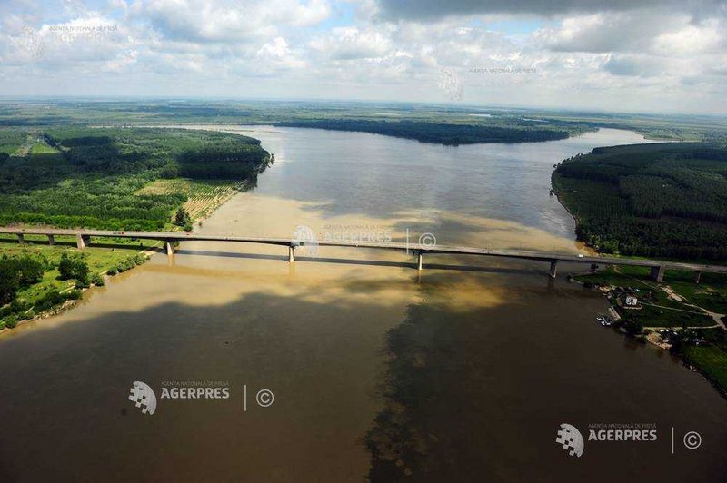
(source: https://foto.agerpres.ro/foto/detaliu/13682033 image taken on 19.05.2010 by CRISTIAN NISTOR / AGERPRES FOTO)
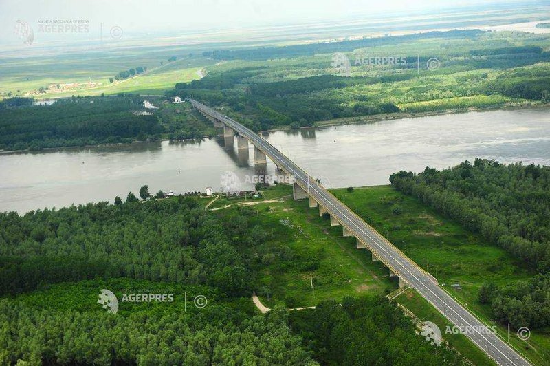
(source: https://foto.agerpres.ro/foto/detaliu/13682032 image taken on 19.05.2010 by CRISTIAN NISTOR / AGERPRES FOTO)
if you scroll down there are next photos

Răchitoasa
- is a former locality in Fetești district. It belonged to Giurgeni commune. Originally called Giurgenii Noi, it came into being after 1951, being established following the deportations to Bărăgan.
Giurgeni
is a commune located on the left bank of the Danube, in Ialomița County, Muntenia, Romania. It is composed of a single village, Giurgeni.
Giurgeni is linked with Vadu Oii–Hârșova over the Danube via the Giurgeni–Vadu Oii Bridge.
(source: https://foto.agerpres.ro/foto/detaliu/13682033 image taken on 19.05.2010 by CRISTIAN NISTOR / AGERPRES FOTO)
(source: https://foto.agerpres.ro/foto/detaliu/13682032 image taken on 19.05.2010 by CRISTIAN NISTOR / AGERPRES FOTO)
if you scroll down there are next photos
-
marika.solo
- Site Admin
- Posts: 21537
- Joined: 29 Sep 2021, 09:38
Re: STOP OVER (favourite places - info, photo, video)
ROMANIA
info, photo - Orasul de Floci (Cetatea de Floci or Târgul de Floci)
- info (eng) e.g. https://en.wikipedia.org/wiki/Ora%C8%99ul_de_Floci (detailed info: https://www.giurgeni.ro/orasuldefloci.html)
- photo galleria e.g. https://www.giurgeni.ro/FOTO/Orasul%20d ... index.html
VIDEO
description under video
FLOCI TOWN
Oraşul de Floci, also Cetatea de Floci or Târgul de Floci is a lost city of Wallachia, now in Romania.
The city was located at the confluence of Ialomiţa River and the Danube, on the old riverbed of the Ialomiţa. The name meant "The Wool City" in Romanian, as it was an important market town. The city is first mentioned in 1431 during the rule of Dan II of Wallachia, but probably existed as trading post in the previous century.
It was set on fire by Stephen III of Moldavia during the wars with Wallachia under the rule of Radu cel Frumos (who was an ally of the Ottoman Empire). The city recovered quickly, but it was once again destroyed by the Polish and Tatar troops of Simion Movilă.
The city finally decayed due to the Russo-Turkish War, 1768-1774, when most inhabitants fled due to the fighting. In the place of the city was formed the village Piua-Petrii, which was destroyed, in turn, during the floods of early 20th century. Currently, the ruins of the city are located in the territory of the Giurgeni commune.
uploaded 19 Aug 2012 by ADRIAN CONSTANTIN
According to contemporaneous accounts, Michael the Brave, the famous Voivode of Wallachia, was born in this city; his birthplace is reportedly the top touristic destination in Ialomița County. (wiki)
PHOTO (Created: 3 April 2018)
Michael the Brave monument near the former of the Floci market town, in present-day Ialomiţa County, Romania
big PHOTO https://upload.wikimedia.org/wikipedia/ ... urgeni.JPG
source: https://upload.wikimedia.org/wikipedia/ ... 0403102611
By Nicu Farcaș - Own work, CC BY-SA 4.0, https://commons.wikimedia.org/w/index.p ... d=67975747
STREET VIEW on this monument (you can rotating the view to both sides - Kuremari's path line there) https://maps.app.goo.gl/fZMw6e6EPX2Qs2h59 image capture Sep 2022
plaque on the monument https://maps.app.goo.gl/XDy1tTQt3XMhHo8P6 Sep 2023
-
marika.solo
- Site Admin
- Posts: 21537
- Joined: 29 Sep 2021, 09:38
Re: STOP OVER (favourite places - info, photo, video)
ROMANIA
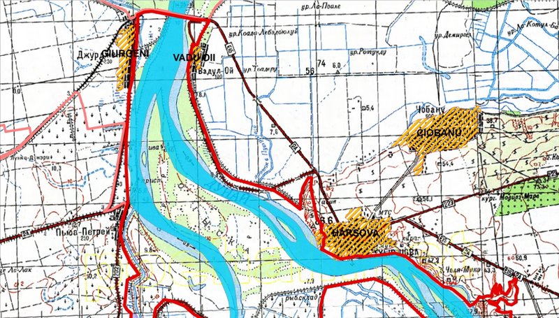
Ramsar Site - Canaralele de la Harsova
... Important Bird Area; 2 Nature Reserves; Natura 2000 Network (SPA, SCI). Situated in the confluence of two Danube branches, Dunarea Veche and Bratul Borcea, on a major migratory route ... (https://rsis.ramsar.org/ris/2113?language=en)
map section (see map https://rsis.ramsar.org/RISapp/files/35 ... anguage=en)
the area on the Gâsca Island (maybe in the spring flooding time)
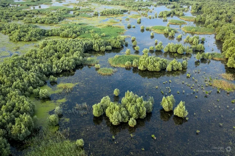
PHOTO https://cdn.adh.reperio.news/image-c/cb ... 26f%3Dwebp
source https://adevarul.ro/stiri-locale/sloboz ... 78014.html
Ramsar Site - Canaralele de la Harsova
... Important Bird Area; 2 Nature Reserves; Natura 2000 Network (SPA, SCI). Situated in the confluence of two Danube branches, Dunarea Veche and Bratul Borcea, on a major migratory route ... (https://rsis.ramsar.org/ris/2113?language=en)
map section (see map https://rsis.ramsar.org/RISapp/files/35 ... anguage=en)
the area on the Gâsca Island (maybe in the spring flooding time)
PHOTO https://cdn.adh.reperio.news/image-c/cb ... 26f%3Dwebp
source https://adevarul.ro/stiri-locale/sloboz ... 78014.html